Military Maps of Scotland (18th century)
| Field | Content |
|---|---|
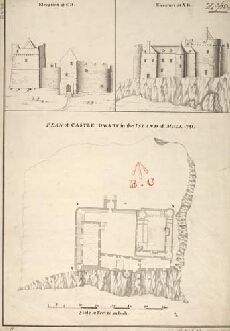
| Title: | Plan of Castle Dwart in the Island of Mull [copy] 1741; Elevation at C,D. Elevation at A,B. |
| Name: | Petit, Lewis (Engineer) |
| Description: | 1 manuscript map ; 498 x 344 mm., on sheet, 514 x 354 mm. |
| Original Survey: | 1741 |
| Date on Map: | 1741 |
| Placename: | Castle Duart |
| Parish: | Torosay |
| County: | Argyllshire |
| Shelfmark: | MS.1648 Z.03/28b |
| Zoom Into Map: | Click on the map to view in greater detail. |
All images © Crown Copyright and © National Library of Scotland