Mapmakers
Your search for Stitt returned 26 records.
Ordered chronologically (undated items first).
| Field | Content | |
|---|---|---|
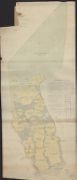
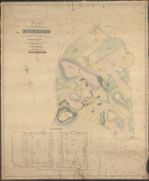
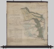
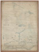
| Name: | Stitt, H., fl. 1826-1866 | |
| Title: | Sketch of the farm of Porterstown in the Parish of Keir | |
| Imprint: | [c. 1820] | |
| Zoom Into Map: | Click on the map to view in greater detail. | |
| Field | Content | |
|---|---|---|
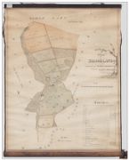
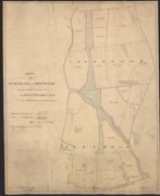
| Name: | Stitt, H., fl. 1826-1866 | |
| Title: | Plan of Brooklands in the Stewarty of Kirkcudbright belonging to Geo. C Jones Esq | |
| Imprint: | 1822 | |
| Zoom Into Map: | Click on the map to view in greater detail. | |
| Field | Content | |
|---|---|---|
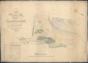
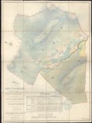
| Name: | Stitt, H., fl. 1826-1866 | |
| Title: | Plan of Strathmilligan in the Parish of Tynron | |
| Imprint: | 1825 | |
| Zoom Into Map: | Click on the map to view in greater detail. | |
| Field | Content | |
|---|---|---|
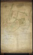
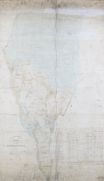
| Name: | Stitt, Henry, ca. 1825-1866 | |
| Title: | Plan of Cairnsmore and Strathmaddie In the Parish of Monigaff and Stewartry of Kirkcudbright the property of James Stewart Esq. | |
| Imprint: | 1827 | |
| Zoom Into Map: | Click on the map to view in greater detail. | |
| Field | Content | |
|---|---|---|
| Name: | Stitt, H., fl. 1826-1866 | |
| Title: | Plan of the Estate of Ernespie in the Parish of Crossmichael | |
| Imprint: | 1829 | |
| Zoom Into Map: | Click on the map to view in greater detail. | |
| Field | Content | |
|---|---|---|
| Name: | ?? Stitt, H., fl. 1826-1866 | |
| Title: | A Plan of the Estate of Scroggiehill | |
| Imprint: | c.1830 | |
| Zoom Into Map: | Click on the map to view in greater detail. | |
| Field | Content | |
|---|---|---|
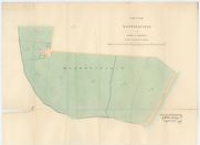
| Name: | Stitt, H., fl. 1826-1866 | |
| Title: | Plan of Townhead of Durisdeer. | |
| Imprint: | 1830 | |
| Zoom Into Map: | Click on the map to view in greater detail. | |
| Field | Content | |
|---|---|---|
| Name: | Stitt, H., fl. 1826-1866 | |
| Title: | Plan of the common muir at Sanquhar | |
| Imprint: | 1830 | |
| Zoom Into Map: | Click on the map to view in greater detail. | |

| Field | Content | |
|---|---|---|
| Name: | Stitt, H., fl. 1826-1866 | |
| Title: | Cleugh | |
| Imprint: | 1830 | |
| Zoom Into Map: | Click on the map to view in greater detail. | |
| Field | Content | |
|---|---|---|
| Name: | Stitt, H., fl. 1826-1866 | |
| Title: | Plan of Little Mark and Upper Glengenny on the estate of Eliock the property of Henry Veitch Esq. | |
| Imprint: | February 1832 | |
| Zoom Into Map: | Click on the map to view in greater detail. | |

| Field | Content | |
|---|---|---|
| Name: | Stitt, H., fl. 1826-1866 | |
| Title: | Plan of Dalfibble | |
| Imprint: | 1835 | |
| Zoom Into Map: | Click on the map to view in greater detail. | |

| Field | Content | |
|---|---|---|
| Name: | Stitt, H., fl. 1826-1866 | |
| Title: | Plan of Auchennaight | |
| Imprint: | 1835 | |
| Zoom Into Map: | Click on the map to view in greater detail. | |
| Field | Content | |
|---|---|---|
| Name: | Stitt, H., fl. 1826-1866 | |
| Title: | Sketch of Burnhead and Croftjane on the Estate of Eccles | |
| Imprint: | 1837 | |
| Zoom Into Map: | Click on the map to view in greater detail. | |
| Field | Content | |
|---|---|---|
| Name: | Stitt, H., fl. 1826-1866 | |
| Title: | Plan of Minniegryle in the Parish of Glencairn and County of Dumfries and also Pointfoot in the parish of Dalry and Stewartry of Kirkcudbright belonging to John Walker Esq. | |
| Imprint: | 1845 | |
| Zoom Into Map: | Click on the map to view in greater detail. | |
| Field | Content | |
|---|---|---|
| Name: | Stitt, H. | |
| Title: | Sketch of Sundaywell | |
| Imprint: | July 1846 | |
| Zoom Into Map: | Click on the map to view in greater detail. | |
| Field | Content | |
|---|---|---|
| Name: | Stitt, H., fl. 1826-1866 | |
| Title: | Plan of part of the Estate of Blackwood Belonging to Will. Copland Esq. of Colliston | |
| Imprint: | August 1847 | |
| Zoom Into Map: | Click on the map to view in greater detail. | |
| Field | Content | |
|---|---|---|
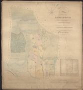
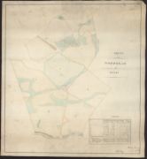
| Name: | Stitt, H., fl. 1826-1866 | |
| Title: | Plan of the Lands of Bardarroch in the Parish of Kirkpatrick-Durham | |
| Imprint: | January 1849 | |
| Zoom Into Map: | Click on the map to view in greater detail. | |
| Field | Content | |
|---|---|---|
| Name: | Stitt, H., fl. 1826-1866 | |
| Title: | Plan of House and Gardens at Townfoot of Sanquhar | |
| Imprint: | 1852 | |
| Zoom Into Map: | Click on the map to view in greater detail. | |
| Field | Content | |
|---|---|---|
| Name: | Stitt, H., fl. 1826-1866 | |
| Title: | Plan of the Lands of Grennan in the parish of Penpont and the county of Dumfries belonging to John Hewetson Esquire | |
| Imprint: | 1853 | |
| Zoom Into Map: | Click on the map to view in greater detail. | |

| Field | Content | |
|---|---|---|
| Name: | Stitt, H., fl. 1826-1866 | |
| Title: | Plan of the Estate of Lawnhall in the parish of Tynron and county of Dumfries belonging to Andrew Pringle Esq. | |
| Imprint: | 1854 | |
| Zoom Into Map: | Click on the map to view in greater detail. | |
| Field | Content | |
|---|---|---|
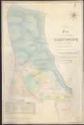
| Name: | Stitt, H., fl. 1826-1866 | |
| Title: | Plan of the lands of Carcoside | |
| Imprint: | 1855 | |
| Zoom Into Map: | Click on the map to view in greater detail. | |
| Field | Content | |
|---|---|---|
| Name: | Stitt, H., fl. 1826-1866 | |
| Title: | Sketch of Woodhead of Eccles | |
| Imprint: | 1856 | |
| Zoom Into Map: | Click on the map to view in greater detail. | |
| Field | Content | |
|---|---|---|
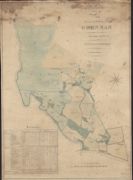
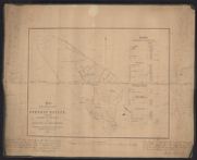
| Name: | Stitt, H., fl. 1826-1866 | |
| Title: | Plan from Ordinance Survey of Forest estate lying in the Parish of Rerwick | |
| Imprint: | 1858 | |
| Zoom Into Map: | Click on the map to view in greater detail. | |
| Field | Content | |
|---|---|---|
| Name: | Johnston, William and Alexander Keith (after Stitt, H.) | |
| Title: | Part of a plan of Kimkarrick and Maxwellfield in the parish of Kirkbean [copied from H Stitt] | |
| Imprint: | 1867 | |
| Zoom Into Map: | Click on the map to view in greater detail. | |
| Field | Content | |
|---|---|---|
| Name: | Johnston, William and Alexander Keith (after Stitt, H.) | |
| Title: | Part of a plan of Kimkarrick and Maxwellfield [Reverse Side] | |
| Imprint: | 1867 | |
| Zoom Into Map: | Click on the map to view in greater detail. | |
| Field | Content | |
|---|---|---|
| Name: | Stitt, H., fl. 1826-1866 | |
| Title: | Section of the Antimony Mines at Glendinning | |
| Imprint: | January 1868 | |
| Zoom Into Map: | Click on the map to view in greater detail. | |