Mapmakers
Your search for Newall, W returned 13 records.
Ordered chronologically (undated items first).
| Field | Content | |
|---|---|---|
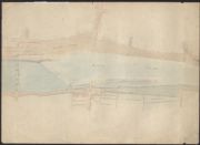
| Name: | Newall, Walter, 1780-1863 | |
| Title: | Untitled [Map of Nith in town showing old bridge, caul etc.] | |
| Imprint: | nd | |
| Zoom Into Map: | Click on the map to view in greater detail. | |
| Field | Content | |
|---|---|---|
| Name: | Newall, Walter, 1780-1863 | |
| Title: | Untitled [Plan or River Nith from Dumfries to Southerness] | |
| Imprint: | nd | |
| Zoom Into Map: | Click on the map to view in greater detail. | |

| Field | Content | |
|---|---|---|
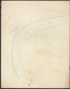
| Name: | Newall, Walter, 1780-1863 | |
| Title: | Untitled [Sketch of the River Nith(?)] | |
| Imprint: | post-1810 | |
| Zoom Into Map: | Click on the map to view in greater detail. | |
| Field | Content | |
|---|---|---|
| Name: | Newall, Walter, 1780-1863 | |
| Title: | Untitled [Sketch of the River Nith, a section of Cargen Pow to Kingholm Merse (paper watermarked 1810)] | |
| Imprint: | post-1810 | |
| Zoom Into Map: | Click on the map to view in greater detail. | |
| Field | Content | |
|---|---|---|
| Name: | Newall, Walter, 1780-1863 | |
| Title: | Copy of Part of the Plan of the Nith by W Newall in 1811 & 1812 [titled in pencil] | |
| Imprint: | C.1812 | |
| Zoom Into Map: | Click on the map to view in greater detail. | |
| Field | Content | |
|---|---|---|
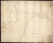
| Name: | Newall, Walter, 1780-1863 | |
| Title: | Untitled [ Plan of the River Nith above the Bridge] | |
| Imprint: | c.1810-c.1850 | |
| Zoom Into Map: | Click on the map to view in greater detail. | |
| Field | Content | |
|---|---|---|
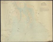
| Name: | Newall, Walter, 1780-1863 | |
| Title: | Chart of the Solway Firth… [copied from the Thomas Winter Chart of 1742 ] | |
| Imprint: | n.d. [c.1810-c.1850] | |
| Zoom Into Map: | Click on the map to view in greater detail. | |
| Field | Content | |
|---|---|---|
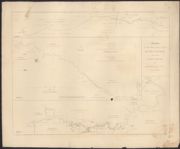
| Name: | Newall, Walter, 1780-1863 | |
| Title: | Untitled [Map of the Solway Firth from Carlisle to Maryport and Airds Point, Kirkcudbrightshire, copied from Robinson'd Admiralty Chart of the Solway Firth, 1837, but extended north to Dumfries] | |
| Imprint: | post-1839 | |
| Zoom Into Map: | Click on the map to view in greater detail. | |
| Field | Content | |
|---|---|---|
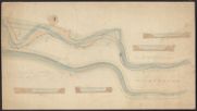
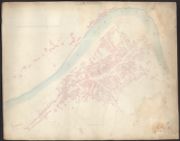
| Name: | Newall, Walter, 1780-1863 | |
| Title: | Untitled [Plan of the River Nith through Dumfries and Maxwelltown] | |
| Imprint: | c.1845 | |
| Zoom Into Map: | Click on the map to view in greater detail. | |
| Field | Content | |
|---|---|---|
| Name: | Newall, Walter, 1780-1863 | |
| Title: | Miniatures of the Three Maps of the River Lochar between the Bridge at Jericho and the Locharwoods Pow, as referred to in the Report [engraving] | |
| Imprint: | nd [c.1845?] | |
| Zoom Into Map: | Click on the map to view in greater detail. | |

| Field | Content | |
|---|---|---|
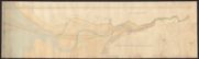
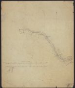
| Name: | Newall, Walter | |
| Title: | Nith - Section from Southerness to Dumfries | |
| Imprint: | 1847 | |
| Zoom Into Map: | Click on the map to view in greater detail. | |
| Field | Content | |
|---|---|---|
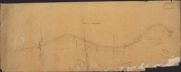
| Name: | Newall, Walter, 1780-1863 | |
| Title: | Untitled [Plan of proposed line of railway between Drungans and Nunland, Troqueer Parish] | |
| Imprint: | c.1855 | |
| Zoom Into Map: | Click on the map to view in greater detail. | |
| Field | Content | |
|---|---|---|
| Name: | Newall, Walter, 1780-1863 | |
| Title: | Untitled [Plan of proposed line of railway between Arbigland, Kirkbean parish and the boundary with New Abbey Parish] | |
| Imprint: | c.1855 | |
| Zoom Into Map: | Click on the map to view in greater detail. | |