Mapmakers
Your search for Morrison, Hector returned 34 records.
Ordered chronologically (undated items first).
| Field | Content | |
|---|---|---|
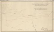
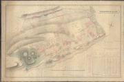
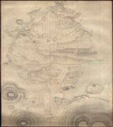
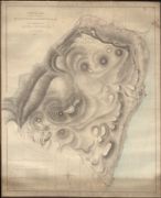
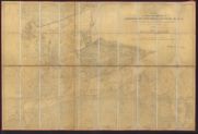
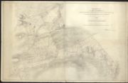
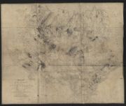
| Name: | Morrison, Hector (fl. 1830-1869) | |
| Title: | Sketch showing the Lines of March mutually agreed upon between Lovat, Chisholm, and Ord by their Minute of Date 15th & 17th October 1836 | |
| Imprint: | 1836 | |
| Zoom Into Map: | Click on the map to view in greater detail. | |
| Field | Content | |
|---|---|---|
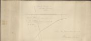
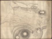
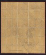
| Name: | Morrison, Hector (fl. 1830-1869) | |
| Title: | Sketch of Trenching at Meikle Phoineas, 1838 | |
| Imprint: | 1838 | |
| Zoom Into Map: | Click on the map to view in greater detail. | |
| Field | Content | |
|---|---|---|
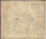
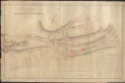
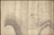
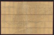
| Name: | Morrison, Hector (fl. 1830-1869) | |
| Title: | Plan of the Hill Grounds of Wester and Mid Aigas showing the disputed marches between Lord Lovat and the Chisholm. | |
| Imprint: | 1838 | |
| Zoom Into Map: | Click on the map to view in greater detail. | |
| Field | Content | |
|---|---|---|
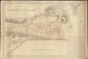
| Name: | McLean & Morrison Surveyors, Inverness McLean, Neil (1824-47) Morrison, Hector (fl. 1830-1869) | |
| Title: | Plan of the Lands of Corrychamuilt, Loanickheim and Others. | |
| Imprint: | 1839 | |
| Zoom Into Map: | Click on the map to view in greater detail. | |
| Field | Content | |
|---|---|---|
| Name: | McLean & Morrison Surveyors, Inverness McLean, Neil (1824-47) Morrison, Hector (fl. 1830-1869) | |
| Title: | Culburnie Lots | |
| Imprint: | 1839 | |
| Zoom Into Map: | Click on the map to view in greater detail. | |
| Field | Content | |
|---|---|---|
| Name: | McLean & Morrison Surveyors, Inverness McLean, Neil (1824-47) Morrison, Hector (fl. 1830-1869) | |
| Title: | The Plan of the Lands of Riesaurie and Ruilick and Dunmore. | |
| Imprint: | 1839 | |
| Zoom Into Map: | Click on the map to view in greater detail. | |
| Field | Content | |
|---|---|---|
| Name: | McLean & Morrison Surveyors, Inverness McLean, Neil (1824-47) Morrison, Hector (fl. 1830-1869) | |
| Title: | Craigscorry & the Adjacent Farm, extending from Kilmorack to Inchrory both inclusive, with the pendicles of Ballechroisk | |
| Imprint: | 1839 | |
| Zoom Into Map: | Click on the map to view in greater detail. | |
| Field | Content | |
|---|---|---|
| Name: | McLean & Morrison Surveyors, Inverness McLean, Neil (1824-47) Morrison, Hector (fl. 1830-1869) | |
| Title: | Plan of the Lands of Farlie, Torgormaig and Others | |
| Imprint: | 1839 | |
| Zoom Into Map: | Click on the map to view in greater detail. | |
| Field | Content | |
|---|---|---|
| Name: | McLean & Morrison Surveyors, Inverness McLean, Neil (1824-47) Morrison, Hector (fl. 1830-1869) | |
| Title: | Plan of the Lands of Farlie, Torgormaig and Others | |
| Imprint: | 1839 | |
| Zoom Into Map: | Click on the map to view in greater detail. | |
| Field | Content | |
|---|---|---|
| Name: | McLean & Morrison Surveyors, Inverness McLean, Neil (1824-47) Morrison, Hector (fl. 1830-1869) | |
| Title: | Stratherrick Plan No III | |
| Imprint: | 1840 | |
| Zoom Into Map: | Click on the map to view in greater detail. | |
| Field | Content | |
|---|---|---|
| Name: | McLean & Morrison Surveyors, Inverness McLean, Neil (1824-47) Morrison, Hector (fl. 1830-1869) | |
| Title: | Stratherrick Plan No IV | |
| Imprint: | 1840 | |
| Zoom Into Map: | Click on the map to view in greater detail. | |
| Field | Content | |
|---|---|---|
| Name: | McLean & Morrison Surveyors, Inverness McLean, Neil (1824-47) Morrison, Hector (fl. 1830-1869) | |
| Title: | Stratherrick Plan No 1 | |
| Imprint: | 1840 | |
| Zoom Into Map: | Click on the map to view in greater detail. | |
| Field | Content | |
|---|---|---|
| Name: | McLean & Morrison Surveyors, Inverness McLean, Neil (1824-47) Morrison, Hector (fl. 1830-1869) | |
| Title: | Plan of the Lands of Dalcattaig and Portclair the Property of the Right Hon Lord Lovat from a Survey in August, 1840 | |
| Imprint: | 1840 | |
| Zoom Into Map: | Click on the map to view in greater detail. | |
| Field | Content | |
|---|---|---|
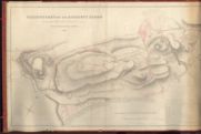
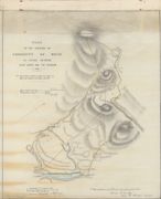
| Name: | Morrison, Hector (fl. 1830-1869) | |
| Title: | Plan of the Grazing for the Commonty of Boah, as divided between the Lord Lovat and The Chisholm, 1843 | |
| Imprint: | 1843 | |
| Zoom Into Map: | Click on the map to view in greater detail. | |
| Field | Content | |
|---|---|---|
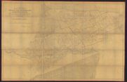
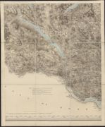
| Name: | Morrison, Hector (fl. 1830-1869) | |
| Title: | Plan of the allotments in the Townships of Brora, East Muir, and Dalchallam, Achrimsdale, Drome, and Clyne Kirkton in the parish of Clyne. Surveyed 1849. Drawn by H. Morrison, 1850, | |
| Imprint: | 1849 | |
| Zoom Into Map: | Click on the map to view in greater detail. | |
| Field | Content | |
|---|---|---|
| Name: | Morrison, Hector (fl. 1830-1869) | |
| Title: | Plan of the Townships of Proncey-Croy, Lednabirichin, Rhiarchar, Astell etc. in the parish of Dornoch. | |
| Imprint: | 1850 | |
| Zoom Into Map: | Click on the map to view in greater detail. | |
| Field | Content | |
|---|---|---|
| Name: | Morrison, Hector (fl. 1830-1869) | |
| Title: | Plan of the Townships of Achavandra, Badininish, Balvraid Muir in the parish of Dornoch, 1850. | |
| Imprint: | 1850 | |
| Zoom Into Map: | Click on the map to view in greater detail. | |
| Field | Content | |
|---|---|---|
| Name: | Morrison, Hector (fl. 1830-1869) | |
| Title: | Plan of the Townships of Proncey-Croy, Lednabirichin, Rhiarchar etc. Showing proposed alterations on the Marches of the lots | |
| Imprint: | 1850? | |
| Zoom Into Map: | Click on the map to view in greater detail. | |
| Field | Content | |
|---|---|---|
| Name: | Morrison, Hector (fl. 1830-1869) | |
| Title: | Plan of the Townships of North Brora Muir, Badanellan, Clyne-Lish Muir, West Clyne-Kirkton in the parish Clyne, 1850. | |
| Imprint: | 1850 | |
| Zoom Into Map: | Click on the map to view in greater detail. | |
| Field | Content | |
|---|---|---|
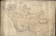
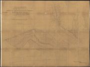
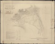
| Name: | Morrison, Hector (fl. 1830-1869) | |
| Title: | Plan of the Arable Lands of the Farm of Pitfour. | |
| Imprint: | 1850 | |
| Zoom Into Map: | Click on the map to view in greater detail. | |
| Field | Content | |
|---|---|---|
| Name: | Morrison, Hector (fl. 1830-1869) | |
| Title: | Rough Plan of the Townships of Achavandra, Badininish, Balvraid Muir, etc., in the Parish of Dornoch ...', surveyed by H. Morrison, 1850 | |
| Date: | 1850 | |
| Zoom Into Map: | Click on the map to view in greater detail. | |
| Field | Content | |
|---|---|---|
| Name: | Burnett, Gregory (fl. 1824-1844) Scott, William (fl. ca. 1830) Morrison, Hector (fl. 1830-1869) | |
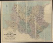
| Title: | Map of the County of Sutherland based on the survey by Burnett and Scott, 1833. With additional names and corrections by Hector Morrison, Inverness, 1853 | |
| Imprint: | 1833, with additional names and corrections 1853 | |
| Zoom Into Map: | Click on the map to view in greater detail. | |
| Field | Content | |
|---|---|---|
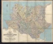
| Name: | Burnett, Gregory (fl. 1824-1844) Scott, William (fl. ca. 1830) Morrison, Hector (fl. 1830-1869) | |
| Title: | Map of the county of Sutherland made on the basis of the trigonometrical survey of Scotland in the years 1831, 1832. 1853 revision - half-inch to the mile. | |
| Imprint: | Edinburgh : W. & A. K. Johnson, [1855] | |
| Zoom Into Map: | Click on the map to view in greater detail. | |
| Field | Content | |
|---|---|---|
| Name: | Burnett, Gregory (fl. 1824-1844)) Scott, William (fl. ca. 1830) Morrison, Hector | |
| Title: | Map of the county of Sutherland made on the basis of the trigonometrical survey of Scotland in the years 1831, 1832 / by Gregory Burnett and William Scott ... with additional names and corrections by Hector Morrison ... 1855. | |
| Imprint: | Edinburgh : W & AK Johnston, [1855] | |
| Zoom Into Map: | Click on the map to view in greater detail. | |
| Field | Content | |
|---|---|---|
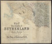
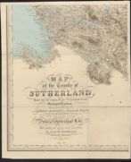
| Name: | Burnett, Gregory (fl. 1824-1844) Scott, William (fl. ca. 1830) Morrison, Hector (fl. 1830-1869) | |
| Title: | Printed map of the County of Sutherland made on the basis of the Trigonometrical Survey of Scotland by Burnett and Scott (reduced version), 1833. With additional names and corrections by Hector Morrison, surveyor, Inverness. | |
| Imprint: | [post 1875] | |
| Zoom Into Map: | Click on the map to view in greater detail. | |
| Field | Content | |
|---|---|---|
| Name: | Burnett, Gregory (fl. 1824-1844)) Scott, William (fl. ca. 1830) Morrison, Hector | |
| Title: | Map of the County of Sutherland; Made on the basis of the Trigonometrical Survey of Scotland, 1831-2. Burnett and Scott. | |
| Imprint: | 1833 | |
| Zoom Into Map: | Click on the map to view in greater detail. | |
| Field | Content | |
|---|---|---|
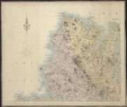
| Name: | Burnett, Gregory (fl. 1824-1844)) Scott, William (fl. ca. 1830) Morrison, Hector | |
| Title: | Map of the county of Sutherland, based on Burnett and Scott's survey, 1833 with additions by Hector Morrison, 1853. South-West Sutherland. | |
| Imprint: | 1833 with additions 1853 [1855] | |
| Zoom Into Map: | Click on the map to view in greater detail. | |
| Field | Content | |
|---|---|---|
| Name: | Burnett, Gregory (fl. 1824-1844) Scott, William (fl. ca. 1830) Morrison, Hector | |
| Title: | Map of the county of Sutherland, based on Burnett and Scott's survey, 1833 with additions by Hector Morrison, 1853. North-West Sutherland. | |
| Imprint: | 1833 with additions 1853 [1855] | |
| Zoom Into Map: | Click on the map to view in greater detail. | |
| Field | Content | |
|---|---|---|
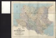
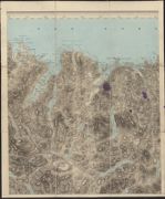
| Name: | Burnett, Gregory (fl. 1824-1844) Scott, William (fl. ca. 1830) Morrison, Hector (fl. 1830-1869) | |
| Title: | Map of the County of Sutherland based on the survey by Burnett and Scott, 1833. With additional names and corrections by Hector Morrison, Inverness, 1853. Revised, 1865. | |
| Imprint: | Revised 1853, additional names and corrections 1868 | |
| Zoom Into Map: | Click on the map to view in greater detail. | |
| Field | Content | |
|---|---|---|
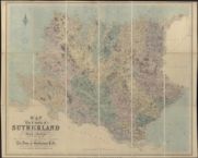
| Name: | Burnett, Gregory (fl. 1824-1844) Scott, William (fl. ca. 1830) Morrison, Hector (fl. 1830-1869) | |
| Title: | Map of the County of Sutherland based on the survey by Burnett and Scott, 1833. With additional names and corrections by Hector Morrison, Inverness, 1853. Revised, 1865. | |
| Imprint: | Revised 1853, additional names and corrections 1868 | |
| Zoom Into Map: | Click on the map to view in greater detail. | |

| Field | Content | |
|---|---|---|
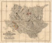
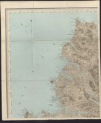
| Name: | Burnett, Gregory (fl. 1824-1844) Scott, William (fl. ca. 1830) Morrison, Hector (fl. 1830-1869) | |
| Title: | Map of the county of Sutherland, made on the basis of the trigonometrical survey of Scotland in the years 1831 1832. 1868 revision - one-inch to the mile. | |
| Imprint: | Edinburgh : W. & A. K. Johnson, [1868] | |
| Field | Content | |
|---|---|---|
| Name: | Burnett, Gregory (fl. 1824-1844) Scott, William (fl. ca. 1830) Morrison, Hector (fl. 1830-1869) | |
| Title: | Map of the County of Sutherland 1853 | |
| Imprint: | [post 1875] | |
| Zoom Into Map: | Click on the map to view in greater detail. | |