Mapmakers
Your search for Mackenzie returned 49 records.
Ordered chronologically (undated items first).
| Field | Content | |
|---|---|---|
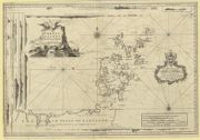
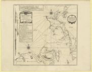
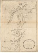
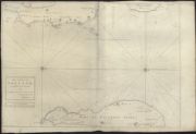
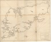
| Name: | MacKenzie, Murdoch (Senior), 1712-1797 | |
| Title: | Orkney Islands | |
| Imprint: | London: Printed for the Author,, in the year MDCCL. [1750] | |
| Zoom Into Map: | Click on the map to view in greater detail. | |
| Field | Content | |
|---|---|---|
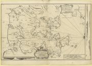
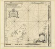
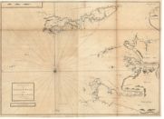
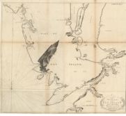
| Name: | MacKenzie, Murdoch (Senior), 1712-1797 | |
| Title: | South isles of Orkney | |
| Imprint: | London: Printed for the Author,, in the year MDCCL. [1750] | |
| Zoom Into Map: | Click on the map to view in greater detail. | |
| Field | Content | |
|---|---|---|
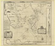
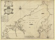
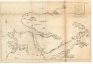
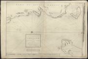
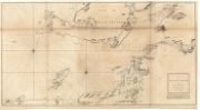
| Name: | MacKenzie, Murdoch (Senior), 1712-1797 | |
| Title: | Pomona or main-land | |
| Imprint: | London: Printed for the Author,, in the year MDCCL. [1750] | |
| Zoom Into Map: | Click on the map to view in greater detail. | |
| Field | Content | |
|---|---|---|
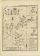
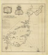
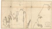
| Name: | MacKenzie, Murdoch (Senior), 1712-1797 | |
| Title: | North east coast of Orkney | |
| Imprint: | London: Printed for the Author,, in the year MDCCL. [1750] | |
| Zoom Into Map: | Click on the map to view in greater detail. | |
| Field | Content | |
|---|---|---|
| Name: | MacKenzie, Murdoch (Senior), 1712-1797 | |
| Title: | North west coast of Orkney | |
| Imprint: | London: Printed for the Author,, in the year MDCCL. [1750] | |
| Zoom Into Map: | Click on the map to view in greater detail. | |
| Field | Content | |
|---|---|---|
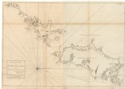
| Name: | MacKenzie, Murdoch (Senior), 1712-1797 | |
| Title: | Lewis or north part of Long-Island | |
| Imprint: | London: Printed for the Author,, in the year MDCCL. [1750] | |
| Zoom Into Map: | Click on the map to view in greater detail. | |
| Field | Content | |
|---|---|---|
| Name: | MacKenzie, Murdoch (Senior), 1712-1797 | |
| Title: | North part of the Lewis | |
| Imprint: | London: Printed for the Author,, in the year MDCCL. [1750] | |
| Zoom Into Map: | Click on the map to view in greater detail. | |
| Field | Content | |
|---|---|---|
| Name: | MacKenzie, Murdoch (Senior), 1712-1797 | |
| Title: | South east coast of the Lewis | |
| Imprint: | London: Printed for the Author,, in the year MDCCL. [1750] | |
| Zoom Into Map: | Click on the map to view in greater detail. | |
| Field | Content | |
|---|---|---|
| Name: | Mackenzie, Murdoch (Senior), 1712-1797 Terry, G. | |
| Title: | A general chart of the west coast and western islands of Scotland from Cantire to Cape Wrath and Butt of the Lewis. | |
| Subtitle: | Plate XIX of Murdoch Mackenzie's 'A maratim survey of Ireland and the west of Great Britain', 1776, vol. II | |
| Imprint: | [London : Mackenzie], 1775. | |
| Zoom Into Map: | Click on the map to view in greater detail. | |
| Field | Content | |
|---|---|---|
| Name: | Mackenzie, Murdoch (Senior), 1712-1797 | |
| Title: | The sound of Mull. | |
| Subtitle: | Plate XXII of Murdoch Mackenzie's 'A maratim survey of Ireland and the west of Great Britain', 1776, vol. II | |
| Imprint: | [London : Mackenzie], 1775. | |
| Zoom Into Map: | Click on the map to view in greater detail. | |
| Field | Content | |
|---|---|---|
| Name: | Mackenzie, Murdoch (Senior), 1712-1797 | |
| Title: | The west side of the island Mull with the islands Tiri and Coll. | |
| Subtitle: | Plate XXIII of Murdoch Mackenzie's 'A maratim survey of Ireland and the west of Great Britain', 1776, vol. II | |
| Imprint: | [London : Mackenzie], 1775. | |
| Zoom Into Map: | Click on the map to view in greater detail. | |
| Field | Content | |
|---|---|---|
| Name: | Mackenzie, Murdoch (Senior), 1712-1797 | |
| Title: | The north part of Sky island and the adjacent main of Scotland. | |
| Subtitle: | Plate XXVI of Murdoch Mackenzie's 'A maratim survey of Ireland and the west of Great Britain', 1776, vol. II | |
| Imprint: | [London : Mackenzie], 1775. | |
| Zoom Into Map: | Click on the map to view in greater detail. | |
| Field | Content | |
|---|---|---|
| Name: | MacKenzie, Murdoch (Senior), 1712-1797 | |
| Title: | The coast of Ireland, near Belfast Loch; with the opposite coast of Scotland: 1775. | |
| Imprint: | 1775 | |
| Zoom Into Map: | Click on the map to view in greater detail. | |
| Field | Content | |
|---|---|---|
| Name: | MacKenzie, Murdoch (Senior), 1712-1797 | |
| Title: | The north east coast of Ireland, from Larn to Rachlin Island; with part of Cantire in Scotland: 1775. | |
| Imprint: | 1775 | |
| Zoom Into Map: | Click on the map to view in greater detail. | |
| Field | Content | |
|---|---|---|
| Name: | Mackenzie, Murdoch (Senior), 1712-1797 | |
| Title: | The south part of Long Island from Bara Head to Benbecula I. | |
| Subtitle: | Plate XXVIII of Murdoch Mackenzie's 'A maratim survey of Ireland and the west of Great Britain', 1776, vol. II | |
| Imprint: | [London : Mackenzie, 1776] | |
| Zoom Into Map: | Click on the map to view in greater detail. | |
| Field | Content | |
|---|---|---|
| Name: | Mackenzie, Murdoch (Senior), 1712-1797 | |
| Title: | The channel between Sky I and the Lewis. | |
| Subtitle: | Plate XXX of Murdoch Mackenzie's 'A maratim survey of Ireland and the west of Great Britain', 1776, vol. II | |
| Imprint: | [London : Mackenzie, 1776] | |
| Zoom Into Map: | Click on the map to view in greater detail. | |
| Field | Content | |
|---|---|---|
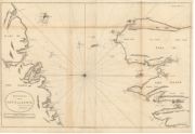
| Name: | Mackenzie, Murdoch (Senior), 1712-1797 | |
| Title: | The Lewis or north part of Long Island. | |
| Subtitle: | Plate XXXI of Murdoch Mackenzie's 'A maratim survey of Ireland and the west of Great Britain', 1776, vol. II | |
| Imprint: | [London : Mackenzie, 1776] | |
| Zoom Into Map: | Click on the map to view in greater detail. | |
| Field | Content | |
|---|---|---|
| Name: | Mackenzie, Murdoch (Senior), 1712-1797 | |
| Title: | The south part of Sky Island and the adjacent main of Scotland. | |
| Subtitle: | Plate XXV of Murdoch Mackenzie's 'A maratim survey of Ireland and the west of Great Britain', 1776, vol. II | |
| Imprint: | [London : Mackenzie], 1776. | |
| Zoom Into Map: | Click on the map to view in greater detail. | |
| Field | Content | |
|---|---|---|
| Name: | Mackenzie, Murdoch (Senior), 1712-1797 | |
| Title: | The west coast of Scotland from Ila to Mull. | |
| Subtitle: | Plate XXI of Murdoch Mackenzie's 'A maratim survey of Ireland and the west of Great Britain', 1776, vol. II | |
| Imprint: | [London : Mackenzie, 1776] | |
| Zoom Into Map: | Click on the map to view in greater detail. | |
| Field | Content | |
|---|---|---|
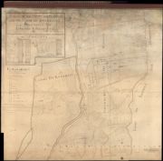
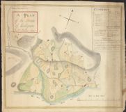
| Name: | Mackenzie, William | |
| Title: | A Plan of the Estate of Reelick and the lands of Knockbain, belonging to Edward S. Fraser Esq | |
| Imprint: | 1789 | |
| Zoom Into Map: | Click on the map to view in greater detail. | |
| Field | Content | |
|---|---|---|
| Name: | Mackenzie, William (1787-1837) | |
| Title: | Plan of the Lands of Culligran | |
| Imprint: | 1799 | |
| Zoom Into Map: | Click on the map to view in greater detail. | |
| Field | Content | |
|---|---|---|
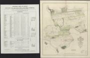
| Name: | Mackenzie, James John Randoll | |
| Title: | Domain of Rosehaugh and the Suddies. The property of Sir James J.R. Mackenzie, Baronet of Scatwell, in the parishes of Avoch, Knockbain, and Rosemarky and County of Ross / by G. Campbell Smith. | |
| Imprint: | Bauff, 1850. | |
| Zoom Into Map: | Click on the map to view in greater detail. | |
| Field | Content | |
|---|---|---|
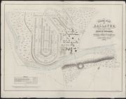
| Name: | Mackenzie, J. Russell. | |
| Title: | Feuing plan of Ballater, being part of the estate of Invercauld, belonging to ... J.R. Farquharson / by J. Russell Mackenzie ... (Keith & Gibb lith.). | |
| Imprint: | [Aberdeen], 1866. | |
| Zoom Into Map: | Click on the map to view in greater detail. | |
| Field | Content | |
|---|---|---|
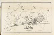
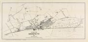
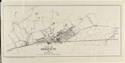
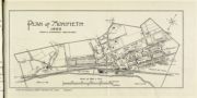
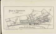
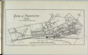
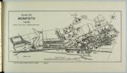
| Name: | Mackenzie, Charles A. (Burgh Surveyor) | |
| Title: | Plan of Monifieth drawn and revised to date by Chas. A. Mackenzie 1909 | |
| Imprint: | [Dundee : James P. Mathew & Co., 1909] | |
| Zoom Into Map: | Click on the map to view in greater detail. | |
| Field | Content | |
|---|---|---|
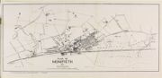
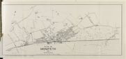
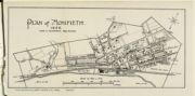
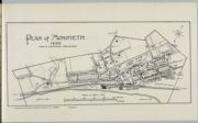
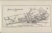
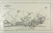
| Name: | Mackenzie, Charles A. (Burgh Surveyor) | |
| Title: | Plan of Monifieth 1910 | |
| Imprint: | [Dundee : James P. Mathew & Co., 1910] | |
| Zoom Into Map: | Click on the map to view in greater detail. | |
| Field | Content | |
|---|---|---|
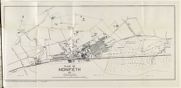
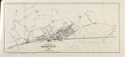
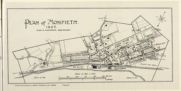
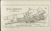
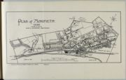
| Name: | Mackenzie, Charles A. (Burgh Surveyor) | |
| Title: | Plan of Monifieth 1911 revised to date by Chas. A. Mackenzie | |
| Imprint: | [Dundee : James P. Mathew & Co., 1911] | |
| Zoom Into Map: | Click on the map to view in greater detail. | |
| Field | Content | |
|---|---|---|
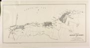
| Name: | Mackenzie, Charles A. (Burgh Surveyor) | |
| Title: | Plan of Newport and Wormit 1911 drawn and revised to date by Chas. A. Mackenzie | |
| Imprint: | [Dundee : James P. Mathew & Co., 1911] | |
| Zoom Into Map: | Click on the map to view in greater detail. | |
| Field | Content | |
|---|---|---|
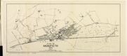
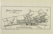
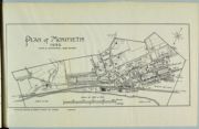
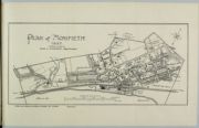
| Name: | Mackenzie, Charles A. (Burgh Surveyor) | |
| Title: | Plan of Monifieth, 1912 | |
| Imprint: | [Dundee : James P. Mathew & Co., 1912] | |
| Zoom Into Map: | Click on the map to view in greater detail. | |
| Field | Content | |
|---|---|---|
| Name: | Mackenzie, Charles A. (Burgh Surveyor) | |
| Title: | Plan of Monifieth, 1913 | |
| Imprint: | [Dundee : James P. Mathew & Co., 1913] | |
| Zoom Into Map: | Click on the map to view in greater detail. | |
| Field | Content | |
|---|---|---|
| Name: | Mackenzie, Charles A. (Burgh Surveyor) | |
| Title: | Plan of Monifieth, 1914 | |
| Imprint: | [Dundee : James P. Mathew & Co., 1914] | |
| Zoom Into Map: | Click on the map to view in greater detail. | |
| Field | Content | |
|---|---|---|
| Name: | Mackenzie, Charles A. (Burgh Surveyor) | |
| Title: | Plan of Monifieth, 1915 | |
| Imprint: | [Dundee : James P. Mathew & Co., 1915] | |
| Zoom Into Map: | Click on the map to view in greater detail. | |
| Field | Content | |
|---|---|---|
| Name: | Mackenzie, Charles A. (Burgh Surveyor) | |
| Title: | Plan of Monifieth, 1920 | |
| Imprint: | [Dundee : James P. Mathew & Co., 1920] | |
| Zoom Into Map: | Click on the map to view in greater detail. | |
| Field | Content | |
|---|---|---|
| Name: | Mackenzie, Charles A. (Burgh Surveyor) | |
| Title: | Plan of Monifieth, 1922 | |
| Imprint: | [Dundee : James P. Mathew & Co., 1922] | |
| Zoom Into Map: | Click on the map to view in greater detail. | |

| Field | Content | |
|---|---|---|
| Name: | Mackenzie, Charles A. (Burgh Surveyor) | |
| Title: | Plan of Monifieth, 1923 | |
| Imprint: | [Dundee : James P. Mathew & Co., 1923] | |
| Zoom Into Map: | Click on the map to view in greater detail. | |
| Field | Content | |
|---|---|---|
| Name: | Mackenzie, Charles A. (Burgh Surveyor) | |
| Title: | Plan of Monifieth, 1925 | |
| Imprint: | [Dundee : James P. Mathew & Co., 1925] | |
| Zoom Into Map: | Click on the map to view in greater detail. | |

| Field | Content | |
|---|---|---|
| Name: | Mackenzie, Charles A. (Burgh Surveyor) | |
| Title: | Plan of Monifieth, 1926 | |
| Imprint: | [Dundee : James P. Mathew & Co., 1926] | |
| Zoom Into Map: | Click on the map to view in greater detail. | |
| Field | Content | |
|---|---|---|
| Name: | Mackenzie, Charles A. (Burgh Surveyor) | |
| Title: | Plan of Monifieth, 1927 | |
| Imprint: | [Dundee : James P. Mathew & Co., 1927] | |
| Zoom Into Map: | Click on the map to view in greater detail. | |
| Field | Content | |
|---|---|---|
| Name: | Mackenzie, Charles A. (Burgh Surveyor) | |
| Title: | Plan of Monifieth, 1928 | |
| Imprint: | [Dundee : Burns & Harris Ltd., 1928] | |
| Zoom Into Map: | Click on the map to view in greater detail. | |
| Field | Content | |
|---|---|---|
| Name: | Mackenzie, Charles A. (Burgh Surveyor) | |
| Title: | Plan of Monifieth, 1929 | |
| Imprint: | [Dundee : Burns & Harris Ltd., 1929] | |
| Zoom Into Map: | Click on the map to view in greater detail. | |
| Field | Content | |
|---|---|---|
| Name: | Mackenzie, Charles A. (Burgh Surveyor) | |
| Title: | Plan of Monifieth, 1930 | |
| Imprint: | [Dundee : Burns & Harris Ltd., 1930] | |
| Zoom Into Map: | Click on the map to view in greater detail. | |
| Field | Content | |
|---|---|---|
| Name: | Mackenzie, Charles A. (Burgh Surveyor) | |
| Title: | Plan of Monifieth, 1931 | |
| Imprint: | [Dundee : Burns & Harris Ltd., 1931] | |
| Zoom Into Map: | Click on the map to view in greater detail. | |
| Field | Content | |
|---|---|---|
| Name: | Mackenzie, Charles A. (Burgh Surveyor) | |
| Title: | Plan of Monifieth, 1932 | |
| Imprint: | [Dundee : Burns & Harris Ltd., 1932] | |
| Zoom Into Map: | Click on the map to view in greater detail. | |
| Field | Content | |
|---|---|---|
| Name: | Mackenzie, Charles A. (Burgh Surveyor) | |
| Title: | Plan of Monifieth, 1933 | |
| Imprint: | [Dundee : Burns & Harris Ltd., 1933] | |
| Zoom Into Map: | Click on the map to view in greater detail. | |

| Field | Content | |
|---|---|---|
| Name: | Mackenzie, Charles A. (Burgh Surveyor) | |
| Title: | Plan of Monifieth, 1934 | |
| Imprint: | [Dundee : Burns & Harris Ltd., 1934] | |
| Zoom Into Map: | Click on the map to view in greater detail. | |
| Field | Content | |
|---|---|---|
| Name: | Mackenzie, Charles A. (Burgh Surveyor) | |
| Title: | Plan of Monifieth, 1935 | |
| Imprint: | [Dundee : Burns & Harris Ltd., 1935] | |
| Zoom Into Map: | Click on the map to view in greater detail. | |
| Field | Content | |
|---|---|---|
| Name: | Mackenzie, Charles A. (Burgh Surveyor) | |
| Title: | Plan of Monifieth, 1936 | |
| Imprint: | [Dundee : Burns & Harris Ltd., 1936] | |
| Zoom Into Map: | Click on the map to view in greater detail. | |
| Field | Content | |
|---|---|---|
| Name: | Mackenzie, Charles A. (Burgh Surveyor) | |
| Title: | Plan of Monifieth, 1937 | |
| Imprint: | [Dundee : Burns & Harris Ltd., 1937] | |
| Zoom Into Map: | Click on the map to view in greater detail. | |
| Field | Content | |
|---|---|---|
| Name: | Mackenzie, Charles A. (Burgh Surveyor) | |
| Title: | Plan of Monifieth, 1938 | |
| Imprint: | [Dundee : Burns & Harris Ltd., 1938] | |
| Zoom Into Map: | Click on the map to view in greater detail. | |
| Field | Content | |
|---|---|---|
| Name: | Mackenzie, Charles A. (Burgh Surveyor) | |
| Title: | Plan of Monifieth, 1938 | |
| Imprint: | [Dundee : Burns & Harris Ltd., 1939] | |
| Zoom Into Map: | Click on the map to view in greater detail. | |