Estate Maps of Scotland, 1730s-1950s
| Field | Content |
|---|---|
| Name: | Boulton, John, 1830-1874 |
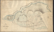
| Title: | Plan of Part of the Lovat Estate in the Lands of Kiltarlity. |
| Imprint: | 1833 |
| Pagination: | 1 manuscript map: col.; 77 x 125 cm. |
| Shelfmark: | Lovat312 |
| Notes: | Shows Ruttle Wood and Fanellan. Map used in legal agreement 1872. Written on outside: Inverness 29 March 1872 Referred to in Comn Lord Lovat & Webster (Witnesses:) David Gordon, David Hall, John H Cowan Comments: focuses on the lands of Fanellan Scale 1:3168. (20 chains = 5" ). Courtesy of Lovat Highland Estates and the North of Scotland Archaeological Society. |
| Zoom Into Map: | Click on the map to view in greater detail. |
Map


