Boundaries viewer - Help
This application shows the boundaries of counties, parishes and unitary authorities in England, Scotland and Wales, ca. 1950s-2020. Many historic records relate to counties and parishes, and it is sometimes useful to view these boundaries, or find the specific county or parish that a place is in. It is also useful to compare these to present-day administrative jurisdictions.
- Main search process
- Specific boundaries shown
- Change date of boundaries
- Search using a Gazetteer
- Search by National Grid Reference, latitude/longitude or Postcode
- Search by Counties/Parishes
- Background map / satellite layers
- Rotation
- Location
- Printing and Image Export/Download
- Bookmarks / Linking to the viewer
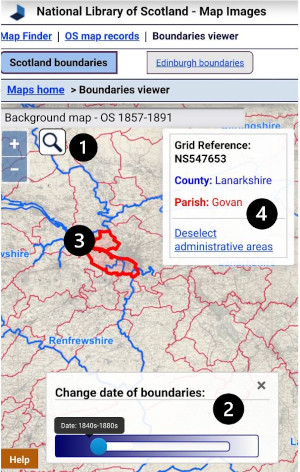
Main search process


- (optionally) Search using placenames
- Choose date of boundaries
- Click on area of interest
- View results
Specific boundaries shown
In Scotland, the map shows the boundaries of counties and parishes in Scotland at three points in time.
- First, as shown on the Ordnance Survey, 1st edition, six-inch to the mile maps, published from the 1840s to the 1880s.
- Second, following the Local Government Act of 1947 and before the Local Government Act of 1973 (when these county and parish jurisdictions were formally abolished). In England and Wales, the 1950s map shows historic county boundaries from ca. 1950.
- Third, modern unitary authorities, districts, civil parishes (in England) and communities (in Wales) have been obtained from OS Boundary Line with grateful thanks.
As our related further information pages on the History and Legislation relating to counties and parishes describe, these boundaries changed at many times in the past and the boundaries shown here only relate to the part of the 19th and 20th century, and the present day.
Go to Boundaries viewer.
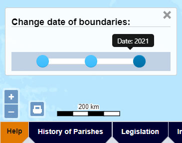
Change date of boundaries (lower left)
Drag the date slider to the lower left to change the date of the boundaries shown.
Go to Boundaries viewer.
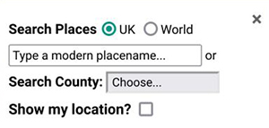
Search using a Gazetteer (top left)
The Search Button ![]() allows you to search using a Gazetteer of Place Names.
allows you to search using a Gazetteer of Place Names.

The Gazetteer at the top of the map search panel allows you to locate your area on the map using modern place names from Nominatim, using OpenStreetMap names, as well as the Definitive Gazetteer for Scotland (PDF, 135KB), developed by Bruce M. Gittings, University of Edinburgh, with funding from the Scottish Government. The OSM Nominatim gazetteer is stronger for larger settlements and street names, as well as for its global coverage, whilst the Definitive Gazetteer for Scotland is particularly strong for smaller rural features in Scotland, such as farms and hamlets, mountains, hills, rivers, streams, and lochs. The two gazetteers are searched collectively using the OSMNames technology.
The map will then position to the place that has been selected.
Search by National Grid Reference, Latitude/Longitude or Postcode (top left)
You can search by British National Grid Reference - 2, 4, 6, 8, or 10 figures (ie. 'SE12', 'NT1234', 'TQ123456', 'SD12345678', 'SD1234567890'). You can also search using numeric Grid References as Eastings and Northings (ie. '123456,123456'), or by using latitute, longitude (ie. '52.123,-2.345').
You can also search by postcode. You can enter just the postcode area (ie. 'EH'), district (ie. 'EH9'), sector (ie. 'EH9 1'), or to the full unit (ie. 'EH9 1SL'), either with a space in the middle (ie. 'EH9 1SL') or without (ie. 'EH91SL'). This uses the Ordnance Survey Open Names API.
When you press 'Enter' or the 'Go' button, the map will then position to the National Grid Reference, latitude/longitude, or postcode that has been entered.
Search by historic counties and parishes (top left)
Further down, drop-down boxes allow counties and parishes (based on their names and boundaries in the 1940s) to be searched. When you select a county, the parishes within that county appear as a second drop-down list, allowing you to select the parish.
We gratefully acknowledge OpenStreetMap, Ordnance Survey, and Bruce M. Gittings, University of Edinburgh for allowing us to use these gazetteers, and the Vision of Britain project for allowing us to use these county and parish boundaries.
Go to Boundaries viewer.
Background map (top left)
By default, the background map shows a modern ESRI Topographic layer. Select the drop-down list to choose a Bing road layer, or Bing satellite or hybrid layers, 1920s mapping from the NLS Historic Maps API, OpenStreetMap, or Ordnance Survey Opendata as background maps.
Rotation (top right)
Hold the [Alt] and [Shift] keys down, and drag with your cursor, or pinch with two fingers on a touch screen to rotate the map. Click/tap on the blue arrow to the upper right, or refresh the page to return to the default rotation.
Location (lower right)
In the lower-right of the map, the location of your mouse position is shown as a British National Grid Reference, as British National Grid Eastings and Northings, and as longitude and latitude.
Go to Boundaries viewer.
Printing and Image Export/Download (lower left)
If you click/tap on the print icon ![]() , to the lower left of the screen, then a print panel opens with various options:
, to the lower left of the screen, then a print panel opens with various options:
- Portrait / landscape orientation
- Page size – A4 to A0
- Margin – 0 to 10 mm
- Scale – 1:500 to 1:1,000,000 - set an exact scale for your map
- North Arrow – off or on
At this stage you can also pan/drag or zoom the map image to make sure its covering exactly the right area of interest.
You can then save the image in various formats – JPEG, PNG, PDF, or copy the image to clipboard. It is also possible to print the map directly to a printer.
Go to Boundaries viewer.
 Bookmarks / Linking to the viewer
The URL in your web browser address bar changes dynamically as you zoom and pan the map, and when you alter visible map layers and overlays. You can copy or bookmark the URL in your web browser address bar to save the current viewer zoom level, location, and layers:
https://maps.nls.uk/geo/boundaries/#zoom=5.0&lat=56.00000&lon=-4.00000&b=1&o=100&dates=2021
- zoom= Map Zoom / Scale / Magnification from 1 to 25
- &lat= Latitude from 0 to 90 +/-
- &lon= Longitude from 0 to 180 +/-
- &b= Background (base) layer, numbered in sequence
- &o= Transparency of Background (base) layer, 0-100
- &dates= Dates of boundaries
You can create any number of bookmarks to start the viewer focused on a specific location and with your choice of layers.
Go to Boundaries viewer.
Supporting information
Read further information on the specific boundaries shown, the history of parishes, legislation, and cartographic information sources on boundaries.
Application
This application uses GeoServer and OpenLayers.
Please email maps@nls.uk for further assistance, or to provide general comments/feedback.

