Estate Maps, 1750s-1900s
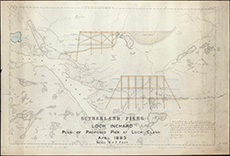
| Title: | Sutherland Piers. Loch Inchard. Plan of proposed Pier at Loch Clash (architectural plans drawn on O.S. 6-inch map) |
| Pagination: | 1 map : col.; 70 x 102 cm |
| Shelfmark: | Acc.10225/269 |
| Notes: | We are very grateful to Sutherland Estates for permission to display this map on our website. Sutherland Estate mapping home page. |
| Zoom Into Map: | Click on the map to view in greater detail. |