Estate Maps, 1750s-1900s
| Name: | Tait, James. |
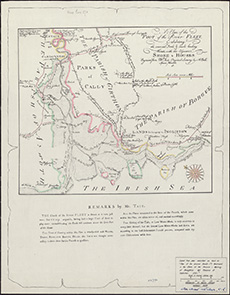
| Title: | A Plan of the foot of the river Fleet exhibiting the several fords & roads leading thereto with the adjacent shore & houses / engraved from Mr. Tait's original survey by A. Bell. |
| Imprint: | Edinburgh, 1934. |
| Pagination: | 1 map ; 298 x 347 mm |
| Shelfmark: | Signet.s.057 |
| Notes: | We are very grateful to the WS Society for their permission to display this map online. View Signet Library collection maps of Scotland held at NLS. |
| Zoom Into Map: | Click on the map to view in greater detail. |