Estate Maps, 1750s-1900s
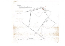

| Title: | Plan of Steading Park, Teachnuik |
| Imprint: | 1910 |
| Pagination: | 1 map; 27 x 29 cm. |
| Shelfmark: | Lovat385 |
| Notes: | 1:3017. (15 chains = 12 cm ). "As Apportioned between Birnie, Wellhouse and Makenzie, Greyfield March 1910. Also shows line of a proposed new access road. Map looks as though it's part of a boundary resolution, possibly sale of land. . Courtesy of Lovat Highland Estates and the North of Scotland Archaeological Society. View Lovat Highland Estates mapping |
| Zoom Into Map: | Click on the map to view in greater detail. |