Estate Maps, 1750s-1900s

| Name: | Ordnance Survey |
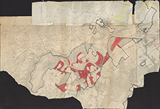
| Title: | [Beauly Beats - Beaufort Castle Roads] |
| Imprint: | 1910s ? |
| Pagination: | 1 map: col.; 106 x 72 cm. |
| Shelfmark: | Lovat369 |
| Notes: | 1:6336. (6" = 1 mile ). Conjoined 2nd edition OS maps, showing in colour the fishing beats around Beaufort Castle. Courtesy of Lovat Highland Estates and the North of Scotland Archaeological Society. View Lovat Highland Estates mapping |
| Zoom Into Map: | Click on the map to view in greater detail. |