Estate Maps, 1750s-1900s
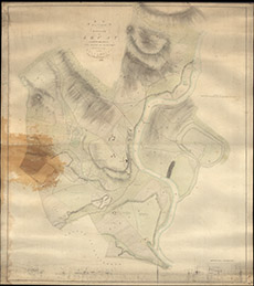

| Title: | A Plan of a Part of the Estate of Lovate comprehending the Mains of Beaufort, Downies and Kiltarlity. Thomas Fraser, 1816 |
| Imprint: | 1816 |
| Pagination: | 1 manuscript map: col.; 145 x 129 cm. |
| Shelfmark: | Lovat356 |
| Notes: | 1:2376. (3 chains = 1" ). Courtesy of Lovat Highland Estates and the North of Scotland Archaeological Society. View Lovat Highland Estates mapping |
| Zoom Into Map: | Click on the map to view in greater detail. |