Estate Maps, 1750s-1900s

| Name: | Morrison, Hector (fl. 1830-1869) |
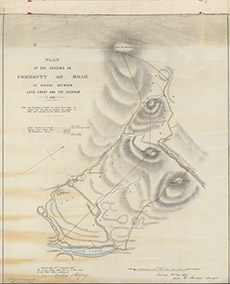
| Title: | Plan of the Grazing for the Commonty of Boah, as divided between the Lord Lovat and The Chisholm, 1843 |
| Imprint: | 1843 |
| Pagination: | 1 manuscript map: col.; 60 x 46 cm. |
| Shelfmark: | Lovat345 |
| Notes: | 1:7920. (40 chains = 4" ). A detailed plan of the allocation of grazing rights in the hill country to the N & W of Loch Fada, N of Erchless. Handwritten on map: Edinburgh 17th August 1867 We hearby certify that this is a true copy of the plan above mentioned. Carfee & Belfridge. Also handwritten on map Netherdale 20th August 1881 This is a correct copy David Gordon Surveyor. Courtesy of Lovat Highland Estates and the North of Scotland Archaeological Society. View Lovat Highland Estates mapping |
| Zoom Into Map: | Click on the map to view in greater detail. |