Estate Maps, 1750s-1900s
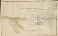

| Title: | Longitudinal Section of Mining Works on Struey |
| Imprint: | 1845 |
| Pagination: | 1 map; 31 x 49 cm. |
| Shelfmark: | Lovat267 |
| Notes: | Shows vertical section through lead mine at Struy, above Strathfarrar, with site of proposed water wheel. Similar to Lovat282. Scale 1:185. (100' = 6.5" ). Courtesy of Lovat Highland Estates and the North of Scotland Archaeological Society. View Lovat Highland Estates mapping |
| Zoom Into Map: | Click on the map to view in greater detail. |