Estate Maps, 1750s-1900s
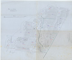

| Title: | A Plan of the Lands of Leanach |
| Imprint: | 1920s ? |
| Pagination: | 1 map; 39 x 47 cm. |
| Shelfmark: | Lovat248 |
| Notes: | A sketch plan of the fields and lands around Leanach, East Clunes, kirkhill parish Scale 1:2376. (15 chains = 5" ). Courtesy of Lovat Highland Estates and the North of Scotland Archaeological Society. View Lovat Highland Estates mapping |
| Zoom Into Map: | Click on the map to view in greater detail. |