Estate Maps, 1750s-1900s

| Name: | HP ? |
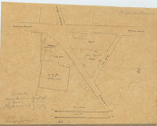
| Title: | [Kirkhill School Grounds, 1876?] |
| Imprint: | 1876 |
| Pagination: | 1 manuscript map; 30 x 40 cm. |
| Shelfmark: | Lovat247-2 |
| Notes: | This rough sketch map is wrapped within Lovat247-1. Signed: HP Inverness 14th Feb 1876, it is presumably the original drawing on which Lovat247-1 was based. Scale 1:464. (3 chains = 13 cm ). Courtesy of Lovat Highland Estates and the North of Scotland Archaeological Society. View Lovat Highland Estates mapping |
| Zoom Into Map: | Click on the map to view in greater detail. |