Estate Maps, 1750s-1900s

| Name: | Gordon, David, 1820-1893 |
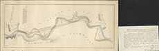
| Title: | Plan of the Proposed March between Inchberry and Lentran, 1862 |
| Imprint: | 1862 |
| Pagination: | 1 map: col.; 23 x 53 cm. |
| Shelfmark: | Lovat242 |
| Notes: | Shows present march between Inchberry and Lentran, and a proposed new march dyke. Rolled up within the map is a paper describing the cost and dimensions of such a dyke. Courtesy of Lovat Highland Estates and the North of Scotland Archaeological Society. View Lovat Highland Estates mapping |
| Zoom Into Map: | Click on the map to view in greater detail. |