Estate Maps, 1750s-1900s

| Name: | Matheson, D. |
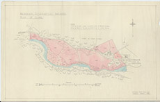
| Title: | Kilmorak Ecclesiastical Buildings. Plan of Glebe |
| Imprint: | 1933 |
| Pagination: | 1 map: col.; 37 x 57 cm. |
| Shelfmark: | Lovat236-1 |
| Notes: | Shows ecclesiastical buildings at Kilmorack, with shaded areas of map representing glebe lands Scale 1:2517. (25 chains = 20 cm ). Courtesy of Lovat Highland Estates and the North of Scotland Archaeological Society. View Lovat Highland Estates mapping |
| Zoom Into Map: | Click on the map to view in greater detail. |