Estate Maps, 1750s-1900s

| Name: | Gordon, David, 1820-1893 |
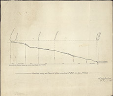
| Title: | Section of the Drains along the Kirkton Burn |
| Imprint: | 1890 |
| Pagination: | 1 map; 33 x 38 cm. |
| Shelfmark: | Lovat222-2 |
| Notes: | Rolled up within Lovat222-1, this seems to be a later map surveyed by David Gordon 5th August 1890. Shows profile of part of the 1853 map, Lovat 222-1 Scale 1:2382. (20 chains = 6.65" ). Courtesy of Lovat Highland Estates and the North of Scotland Archaeological Society. View Lovat Highland Estates mapping |
| Zoom Into Map: | Click on the map to view in greater detail. |