Estate Maps, 1750s-1900s
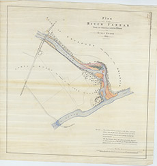

| Title: | Plan of the River Farrar from its Junction with the Glass to Struy Bridge, 1864 |
| Imprint: | 1864 |
| Pagination: | 1 manuscript map: col.; 57 x 56 cm. |
| Shelfmark: | Lovat221 |
| Notes: | Shows the refashioning and straightening of this junction. One of many estate maps detailing the junction of the Farrar and Glass (Beauly) rivers. Scale 1:3960. (25 chains = 5" ). Courtesy of Lovat Highland Estates and the North of Scotland Archaeological Society. View Lovat Highland Estates mapping |
| Zoom Into Map: | Click on the map to view in greater detail. |