Estate Maps, 1750s-1900s

| Name: | Gordon, David, 1820-1893 |
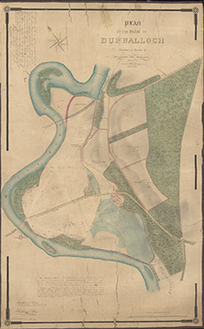
| Title: | Plan of the Farm of Dunballoch, situated in the parishes of Kiltarlity and Kirkhill, 1847 |
| Imprint: | 1847 |
| Pagination: | 1 manuscript map: col.; 92 x 57 cm. |
| Shelfmark: | Lovat204 |
| Notes: | This 1847 map is over-written with details of two dispositions in May and November 1853. Scale 1:3168. (25 chains = 6.25" ). Courtesy of Lovat Highland Estates and the North of Scotland Archaeological Society. View Lovat Highland Estates mapping |
| Zoom Into Map: | Click on the map to view in greater detail. |