Estate Maps, 1750s-1900s
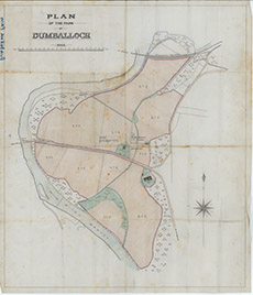

| Title: | Plan of the Farm of Dumballoch |
| Imprint: | 1910s ? |
| Pagination: | 1 map: col.; 84 x 72 cm. |
| Shelfmark: | Lovat203 |
| Notes: | An undated, unsigned map of the farm of Dumballoch, near Kirkhill, and surrounding fields. Scale 1:2526. (1000' = 4.75" ). Courtesy of Lovat Highland Estates and the North of Scotland Archaeological Society. View Lovat Highland Estates mapping |
| Zoom Into Map: | Click on the map to view in greater detail. |