Estate Maps, 1750s-1900s
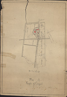

| Title: | Plan of Lands of Croyard |
| Imprint: | 1870s ? |
| Pagination: | 1 map: col.; 62 x 44 cm. |
| Shelfmark: | Lovat181 |
| Notes: | Focussed on Croyard Farm, this plan shows the Croyard Road from Beauly to Croyard House. Undated, but shows the railway that was built in early 1860's Courtesy of Lovat Highland Estates and the North of Scotland Archaeological Society. View Lovat Highland Estates mapping |
| Zoom Into Map: | Click on the map to view in greater detail. |