Estate Maps, 1750s-1900s

| Name: | McLean & Morrison Surveyors, Inverness McLean, Neil (1824-47) Morrison, Hector (fl. 1830-1869) |
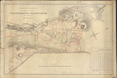
| Title: | Plan of the Lands of Corrychamuilt, Loanickheim and Others. |
| Imprint: | 1839 |
| Pagination: | 1 manuscript map: col.; 67 x 99 cm. |
| Shelfmark: | Lovat161 |
| Notes: | These settlements are not listed specifically on OS maps, but refer to Camault Mor south of Kiltarlity Scale 1:2376. (30 chains = 10" ). Courtesy of Lovat Highland Estates and the North of Scotland Archaeological Society. View Lovat Highland Estates mapping |
| Zoom Into Map: | Click on the map to view in greater detail. |