Estate Maps, 1750s-1900s

| Name: | Morrison, Hector (fl. 1830-1869) |
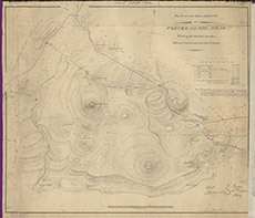
| Title: | Plan of the Hill Grounds of Wester and Mid Aigas showing the disputed marches between Lord Lovat and the Chisholm. |
| Imprint: | 1838 |
| Pagination: | 1 manuscript map: col.; 58 x 66 cm. |
| Shelfmark: | Lovat099 |
| Notes: | Map used in an 1842 disposition to settle the march between Lovat & Chisholm. Details are handwritten at bottom right. Scale 1:4628. (40 chains = 6.7" ). Courtesy of Lovat Highland Estates and the North of Scotland Archaeological Society. View Lovat Highland Estates mapping |
| Zoom Into Map: | Click on the map to view in greater detail. |