Estate Maps, 1750s-1900s
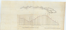

| Title: | Proposed Road to Mallaig Pier: Section along the Centre of the Proposed Road |
| Imprint: | 1910s ? |
| Pagination: | 1 map: col.; 42 x 98 cm. |
| Shelfmark: | Lovat071 |
| Notes: | No date but seems old map. Talks of chains and furlongs Scale 1:3960. (40 chains = 8" ). Courtesy of Lovat Highland Estates and the North of Scotland Archaeological Society. View Lovat Highland Estates mapping |
| Zoom Into Map: | Click on the map to view in greater detail. |