Estate Maps, 1750s-1900s
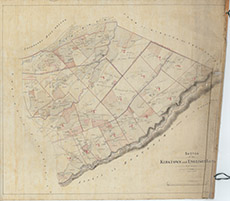

| Title: | Sketch of the Kirktown & Englishtown Lots |
| Imprint: | 1860 |
| Pagination: | 1 manuscript map: col.; 66 x 75 cm. |
| Shelfmark: | Lovat059 |
| Notes: | Maps shows allocation of lots at Kirkton and Englishton, with much subsequent handwritten changes and comments Scale 1:3168. (1 chain = ¼" ). Courtesy of Lovat Highland Estates and the North of Scotland Archaeological Society. View Lovat Highland Estates mapping |
| Zoom Into Map: | Click on the map to view in greater detail. |