Estate Maps, 1750s-1900s
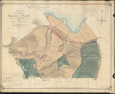

| Title: | Plan of the Farm of Englishtown & Kirkton |
| Imprint: | 1852 |
| Pagination: | 1 manuscript map: col.; 62 x 76 cm. |
| Shelfmark: | Lovat058 |
| Notes: | Map used in a lease agreement between Lord Lovat and John Ross, 1868. Handwriting on front of map provides details. Scale 1:3168. (1 chain = ¼" ). Courtesy of Lovat Highland Estates and the North of Scotland Archaeological Society. View Lovat Highland Estates mapping |
| Zoom Into Map: | Click on the map to view in greater detail. |