Estate Maps, 1750s-1900s
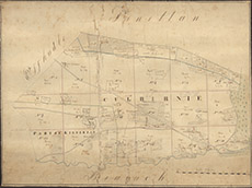

| Title: | [Culburnie] |
| Imprint: | 19th century |
| Pagination: | 1 manuscript map; 38 x 52 cm. |
| Shelfmark: | Lovat054 |
| Notes: | An un-dated and un-signed map of Culbirnie, near Kiltarlity Scale 1:3168. (10 chains = 2.5" ). Courtesy of Lovat Highland Estates and the North of Scotland Archaeological Society. View Lovat Highland Estates mapping |
| Zoom Into Map: | Click on the map to view in greater detail. |