Estate Maps, 1750s-1900s

| Name: | Gordon, David, 1820-1893 |
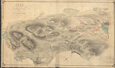
| Title: | Plan of the Lands of Fanblair and Ardblair, situated in the Parish of Kiltarlity |
| Imprint: | 1846 |
| Pagination: | 1 manuscript map: col.; 75 x 123 cm. |
| Shelfmark: | Lovat049 |
| Notes: | 1:3960. (10 chains = 2" ). Courtesy of Lovat Highland Estates and the North of Scotland Archaeological Society. View Lovat Highland Estates mapping |
| Zoom Into Map: | Click on the map to view in greater detail. |