Estate Maps, 1750s-1900s
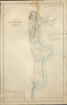

| Title: | Plan of the Low Lands of Easter Main and Leimgorry. |
| Imprint: | 1859 |
| Pagination: | 1 manuscript map: col.; 65 x 42 cm. |
| Shelfmark: | Lovat043 |
| Notes: | Map used in an 1861 disposition. Handwritten on top right, Beauly 8th June 1861 Scale 1:3960. (10 chains = 2" ). Courtesy of Lovat Highland Estates and the North of Scotland Archaeological Society. View Lovat Highland Estates mapping |
| Zoom Into Map: | Click on the map to view in greater detail. |