Estate Maps, 1750s-1900s

| Name: | Boulton, John, 1830-1874 |
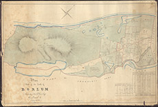
| Title: | Pland Part of the Lands of Borlum Property of Thos A FraserEsq of Lovat |
| Imprint: | 1827 |
| Pagination: | 1 manuscript map: col.; 44 x 67 cm. |
| Shelfmark: | Lovat015 |
| Notes: | A map of the croft allocation between the Caledonian Canal and the River Tarff, south of Fort Augustus Scale 1:3168. (4 chains = 1" ). Courtesy of Lovat Highland Estates and the North of Scotland Archaeological Society. View Lovat Highland Estates mapping |
| Zoom Into Map: | Click on the map to view in greater detail. |