Estate Maps, 1750s-1900s

| Name: | Bruce, Robert |
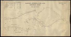
| Title: | Glasgow - Inverness Road A82 Inverness-shire |
| Imprint: | 1930 |
| Pagination: | 1 map: col.; 79 x 151 cm. |
| Shelfmark: | Lovat009 |
| Notes: | A map pf the lower end of Loch Ness and Fort Augustus area, showing plans for a new road, the A82. Scale 1:1200. (1" = 100' ). Courtesy of Lovat Highland Estates and the North of Scotland Archaeological Society. View Lovat Highland Estates mapping. |
| Zoom Into Map: | Click on the map to view in greater detail. |