Estate Maps, 1750s-1900s
| Name: | Aitken, David |
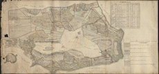
| Title: | Plan of the Lands and Barroney of Drynie - the Property of Colonel Colin Graham - made out from an accurate Survey by David Aitken 1786 |
| Imprint: | 1786 |
| Pagination: | 1 manuscript map: col.; 74 x 158 cm. |
| Shelfmark: | Drynie a,b |
| Notes: | (12 chains = 12 cm ). Courtesy of the North of Scotland Archaeological Society. View Lovat Highland Estates mapping. |
| Zoom Into Map: | Click on the map to view in greater detail. |