Estate Maps, 1750s-1960s
| Field | Content |
|---|---|
| Title: | Plan and Sections of Outfall Drain along the North Side of the Culburnie Crofts, 1849 |
| Imprint: | 1849 |
| Pagination: | 1 map: col.; 45 x 74 cm. |
| Shelfmark: | Lovat185 |
| Notes: | 1:2,400 (20 chains = 6.6") Courtesy of Lovat Highland Estates and the North of Scotland Archaeological Society. |
| Zoom Into Map: | Click on the maps below to order images or view in greater detail. |
Map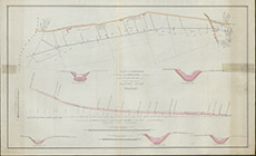
|
Reverse side
|
