Estate Maps, 1750s-1960s
| Field | Content |
|---|---|
| Name: | Gordon, David (1820-1893) |
| Title: | Plan of Lower Ardnagrask and Moor of Ord, the Property of the Right Honourable Lord Lovat Surveyed 1864-6. |
| Imprint: | 1864-6 |
| Pagination: | 1 map; 156 x 78 cm. |
| Shelfmark: | Lovat106 |
| Notes: | Scale: 1:1,584 (10 chains = 5") Courtesy of Lovat Highland Estates and the North of Scotland Archaeological Society. |
| Zoom Into Map: | Click on the maps below to order images or view in greater detail. |
Map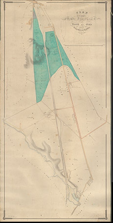
|
Reverse side
|
