Estate Maps, 1750s-1960s
| Name: | Ordnance Survey |
| Title: | Lands offered to Board of Agriculture for Scotland for settlement of discharged soldiers, 18th April 1919. |
| Imprint: | 1919 |
| Pagination: | 1 map: col.; 39 x 34 cm. |
| Shelfmark: | Lovat075 |
| Notes: | Scale: 1:10,560 (6" = 1 mile). Courtesy of Lovat Highland Estates and the North of Scotland Archaeological Society. |
| Zoom Into Map: | Click on the maps below to order images or view in greater detail. |
Map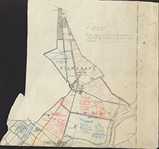
|
Reverse side
|
