Estate Maps, 1772-1878
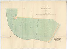
| Title: | Part of a plan of Kimkarrick and Maxwellfield in the parish of Kirkbean [copied from H Stitt] Reverse side of map included for information. |
| Imprint: | 1867 |
| Pagination: | 1 manuscript map: col.; 43 x 59 cm.; 1 manuscript; 43 x 59 cm. |
| Shelfmark: | - |
| Notes: | Courtesy of Mr Jamie Blackett through the Dumfries Archival Mapping Project |
| Zoom Into Map: | Click on the maps below to order images or view in greater detail. |
 |
 |