Maps of Scotland
| Field | Content |
|---|---|
| Name: | Pont, Timothy, 1560?-1614? |
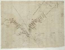
| Title: | [West Water and Noran Water ] - Pont 30 (back) |
| Imprint: | [ca. 1583-96] |
| Pagination: | 1 manuscript map ; 28 x 37 cm. |
| Shelfmark: | Adv.MS.70.2.9 (Pont 30v) |
| Notes: | The manuscript known as Pont 30 contains 6 maps in total. Four are on the front of the sheet. Shown here are the two maps, referred to as Pont 30(5) and Pont 30(6) which appear on the back of the sheet, separated by a double line. Pont 30(5) is a map of the upper valley of the Noran Water, including Glen Ogil, from the headwaters to Waine C:[astle] (Dayne Castle), 3km north of Finavon on the River South Esk. A stretch of the upper course of the South Esk is also shown. Pont 30(6) shows the course of the West Water from its headwaters to Edzell Castle. To the west Pont shows the head of the River Norain (the Noran Water) and the lower course of the Paphrie Burn which joins with the West Water just south east of Blairnay (Blairno).
Pont 30(5) The valley of the Noran Water it is 8 myles betuix [th]e springs of Mem: all fro[m] the Courtfoord Pont 30(6) The valley of the West Water
Par: of Neurr & View the Pont Maps website. View maps by Blaeu and Robert and James Gordon. |
| Zoom Into Map: | Click on the map to view in greater detail. |