County maps, 1580s-1950s
| Field | Content |
|---|---|
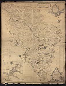
| Name: | Ross, Charles, 1722-1806 |
| Title: | A map of the shire of Lanark taken from an actual survey and laid down from a scale of an inch to a mile / by Charles Ross ... Engraved by Geo. Cameron. |
| Imprint: | [S.l.], 1773. |
| Pagination: | 1 map ; 122 x 97 cm |
| Shelfmark: | Signet.s.038 |
| Notes: | We are very grateful to the WS Society for their permission to display this map online. View Signet Library collection maps of Scotland held at NLS. |
| Zoom Into Map: | Click on the map to view in greater detail. |