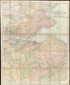
County maps, 1580s-1950s
| Field | Content |
|---|---|
| Name: | Bartholomew, John Junior, 1831-1893 |
| Title: | Reduced Ordnance Survey map of the Lothians & Fife with parts of their adjacent counties / by John Bartholomew ... Coloured to show the new parish & county boundaries etc. |
| Imprint: | [Edinburgh, 1891?] |
| Pagination: | 1 map ; 1053 x 853 mm. |
| Shelfmark: | EMS.b.2.22 |
| Zoom Into Map: | Click on the map to view in greater detail. |