Pont maps | Pont texts | biographies | history | subjects | further reading
Pont Maps of Scotland, ca. 1583-1614 - Pont texts
Stra-Okell, Stra-charroun
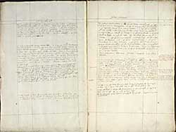
Pagination: 122v-123r
Notes:
Many of these placenames and this area are shown on Gordon 10 and Gordon 19.
Transcription of text:
Stra-Okell
Beginning at Dornoch in Suthirland, a myl thence up the ferry Dilleg, a myl thence is Shyra, a myl thence Skibo, with a water betuix, half a myl thence Pul-rossie, with a salt water loch and a burn falling in the head therof, a myl from that Achacharrich with a good hous and a burne. twa myl thence Spanyedal with Avon Spanyedal thrie myl long, with Loch Migedal a myl long, with ylen loch Migedall with a hous in it, a myl up the water of Spanyadal Cruiks with a kirk, a myl thence Sowerdil, a myl thence Makel, a myl thence Innersinn.
The water of Straokell runneth straicht east, it is 30 myl betuix Bra- straokell and the toun of Tayne. it is 4 myl betuix Bra-stra-okel and Bra-charroun, that bounds is called Bin Achnagowen. Item the head of the water of alt-Gellagach cumeth out of Assyn, and is march betuix Assyn and Bra-Stra-okel. Item the burne of Alt-Leadmoir runneth out of loch-na-laid-moir the said Loch a myl long and falleth in Okell.
Monie-Helaeg is the wilderness upon Bra-stra-okell. Six myl from Loch-na-layd-moir is Turnaeg-ocrach upon the north syd of Okel, hard by is Turnaeg Icrach, a myl beneth that on the southsyd of Okel is Langol, half a myl thence is Bra-straokel down a quarter myl thence is ,from it twa myl is Tenuck. Tenuck is above the river mouth of Okel 2 myl.
Following up the river Okel fra the mouth, neerest Ochtow is Brae on the southsyd 1 myl then a myl above it on that same syd Amad. 2 myl above it Keurny and 1/2 myl above that Cragy. on the northsyd is six myl above the mouth therof is Kean-loch-ailsh. Turnaeg Icra is benethe it on that same syde I myl 1/2 myl, Turnaeg ocra above it on that same syd Turnaeg ocra half a myl. beneth the lowest Ocra on that same syd is Tuytimtervah 2 myl. beneth that on the north syd still is Knoken with a kirk 1/4 myl. then is Innerchassill a myl and half. heir the water of Chasla devydes Straokel fra Suthirland.
Ther is up Chassil on Straokel syd Glenchassil a seat up the water 2 myl and a litle above it on that same syd 1/4 myl is a seat cald Glenmuik.
The lenght of Ross is 50 myle from Kintaill to Tervatnesss the breadth therof from the Stok foord or nordeastsyd of the River Farrar parting it from the Bishoprik of Murray is 30 myl to Assin whilk is in the Bishoprik of Cathnes
[This statement appears also on p 4/5]
Stra-charroun
The head of Strath-carrown is 30 myl fra Tayne south-southwest
[It is rather W.N.W.]
The uppermost town on it is Achanagowen, twa myl be north the head of Glenmoir, whilk is the uppermost branche of the water of Carrown, a myl thence Esbulg with avon Esbulg 6 my1 long, the said river cumeth out of Cory-Voynlie and runneth in upon the north syde of Carrown. 2 myl thence Amad. a myl thence Amad-na-heglise with gryt firr woods, thes twa Amads upon the north syd of Carrown a myl thence on the southsyd Crunnord-ocrach, and half a myle thence Alt Crunnord, half a myl thence Crunnord-icrach. 3 myl thence Downielaerne, with a burne betuix them. a myle thence Layd-Clamag, ovir on the mouth of Carrown as it falIeth in the sea is Inner Carrown hard on the north syd of it. A myle thence on the northsyd of Carrown is Knokin-arrow, hard by it is Langel-icrach, ane myl from it is Langel-ocrach, 2 myl thence Scudechaell and then ther ar no more seats upon Charrown.
Hils in Stracharrown. Frie water, Iskinavar Coryvoynlie with the hills of Glenmoir.
[The Firth of Tayne from Tervartness runneth up 24 myl, opening to the southward as al the draught of it looketh]
There ar in Stracharron Kilmachalmag, upon the ferry that goeth up to Okell river, with a chappell, and a burn of that name 4 myl long, cuming down from Bra-Stracharrown. 2 myl from Kilmachalmag downward is Auchinnagart. 2 myl thence Teneneur. 2 myl therfra Carbisdail with a burne be east and a Chewlis. myl and 1/2 myl therfra the seat of Inner-charrown 2 myl from Inner-charron eastward is Kincarn kirk with a town and a burne. 2 myl therfra Faern ocrach a myl therfra Faern lcrach with alt-Faern 5 myl long. half a myl thence Dun-Alliskaeg with great ruynes of a Pichtish fort or sum uther auncient building.
[Betuix Tayn and Kincardyn ar 8 myl, the sea filleth up above Kincarne 14 myl.]
2 myl from Faern Icrach is Dunivastray, half a myl therfra is Ard-moir, a myl thence Dallash beg, with avon Dallash, hard by Dallash moir upon the uthir syd of thir avon, hard by that is Balinlich, and hard by it Edir- Din, with a kirk, a myl therfra is Camiscurry. hard by Tarlagy. a myl thence to Balegowich or Tayne. Item Teabrek a myl fra Tayne. heir was the laird of Balnagown killed upon the bank of Alt-Row.
[Loch Synn in Sutherland is 12 myl long, and the river, after it cum from the loch to the fall in the firth of Charrown is 6 myl.]
It is 24 or 25 myl betuix Kincarne kirk beneth Innercharron and loch bruyne the string way is up the water Okell upon 2 myl and then throw the month.
Betuix Ardbrak in Assyn and Innercharron is about 30 myl the way is up Okel river 7 myl and then north throw the months.
Betuix Skormyvarr whair Charron springeth and Tayn 30 myl. Coygach is at the west of Skor-myvarr.


