Pont maps | Pont texts | biographies | history | subjects | further reading
Pont Maps of Scotland, ca. 1583-1614 - Biographies
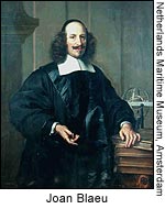
Joan Blaeu (c. 1599-1673) by Christopher Fleet

Joan
Blaeu was the eldest son of Willem Janszoon Blaeu (1571-1638), and
was probably born in Alkmaar in the province of Noord-Holland in the
final years of the 16th century. He was brought up in Amsterdam, and
studied law at the University of Leiden before going into partnership
with his father in the 1630s. Although his father Willem had cartographic
interests, having studied under the Danish astronomer Tycho Brahe
and having manufactured globes and instruments, his primary business
was as a printer. It was under the control of Joan that the Blaeu
printing press achieved lasting fame by moving towards the printing
of maps and expanding to become the largest printing press in Europe
in the 17th century.
Until the late 1620s, the European market for world atlases was dominated
by the Mercator maps published by Jodocus Hondius II. However, following
the latter's death in 1629, and the growing competition in publishing
sea charts and pilot books, the Blaeu business seized its opportunity
to publish a grand world atlas: Theatrum Orbis Terrarum or
Atlas novus. Willem had already built up extensive contacts
across Europe with those who could supply cartographic and topographic
information about particular countries (such as Sir
John Scot of Scotstarvit in the case of Scotland) and Joan continued
to develop these through active correspondence. A small part of this
correspondence, amounting to fifteen letters dated between 1626 and
1657 from Blaeu to Sir John Scot of Scotstarvit, survives in the National
Library of Scotland (Adv.MS.17.1.9; Moir and Skelton, 1968).
Progress on the world atlas was initially slow, and by the time of
Willem's death in 1638 only two volumes had been published, although
several more were in progress. But with the publication of a volume
for Italy in 1640, one for England in 1645, and another for Scotland
in 1654, Joan Blaeu eclipsed his chief rival, Johannes Janssonius,
who from this time never matched the quantity of volumes and maps
in Blaeu's magnificent atlas. Recognising that the wealthy patrons
who would buy such atlases were primarily interested in display, aesthetic
considerations such as luxury bindings, fine engraving, bright colour
and beautiful typography were emphasised. The currency of the maps,
many of which (as for Scotland) had been drafted over a half-century
earlier, and an even geographical spread across the known world, were
definitely considered less important.
By the 1660s the Theatrum Orbis Terrarum (or Atlas Maior
as it had became known by this time) had expanded to between 9 and
12 volumes, depending on the language. With over 3,000 text pages
and approximately 600 maps, it was the most expensive book money could
buy in the later 17th century. The translation of the text from Latin
into Dutch, English, German, French, and Spanish for several volumes
created enormous work for those involved in typography and letterpress
activities. It is estimated that over 80 men must have been employed
full-time in the Blaeu printing house in Bloemgracht (not including
engravers who worked elsewhere), with over 15 printing presses running
simultaneously, and in 1667 a second press was acquired at Gravenstraat.
At the same time as producing the Atlas Maior, Blaeu was also
publishing town plans of Italy, maps for globes, and other volumes.
At its peak the Blaeu press managed to produce over 1 million impressions
from 1,000 copper plates within four years (Koeman, 1970).
This growth coincided with a period of prosperity for Amsterdam and
the Low Countries, and Joan Blaeu's career mirrored this success.
He became chief cartographer to the Dutch East India Company from
1638, and from 1651 to 1672 he served on the Amsterdam City Council
without a break, holding several public offices. He also invested
in Dutch colonial interests in North America. He had married in 1634,
and by this time had three sons and three daughters; however, disaster
was about to strike.
In February 1672 a fire broke out in the main printing press at Gravenstraat.
There are conflicting accounts of the episode, but it is clear that
the damage was enormous, destroying not only thousands of paper sheets
and printed maps, but also copper plates and metal for type, both
of which melted in the heat. Although his other press at Bloemgracht
continued, the loss for Joan Blaeu must have been considerable. The
situation was made worse by Blaeu's fall from political office under
the new regime of William III (of Orange) later in the year. Many
of his surviving copper plates were sold, particularly to Pieter Mortier
and Frederick de Wit. In December 1673, Joan Blaeu died, leaving his
22-year-old son Joan Blaeu II in control of the company. The Blaeu
press continued to publish maps and other works, but its heyday was
over, and the firm ceased operations in the early years of the 18th
century. A great era in cartographic history was over.
