Military Maps of Scotland (18th century)
Your search returned 2 records.
Ordered chronologically (undated items first).
| Field | Content | |
|---|---|---|
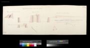
| Title: | Profils of the Proposed Additional Works at Fort Augustus [1746] [copy]; Profile of the Fort through the Courtine; Profile of the Ravelin; Profile of the Covered Way and Glacies; Profil through the Line A.B in the Plan; Profile of the Entrenchment before | |
| Name: | Marcell, Lewis (Engineer) Read, William (Copyist) | |
| Survey: | 1746 | |
| Shelfmark: | MS.1647 Z.02/64c | |
| Field | Content | |
|---|---|---|
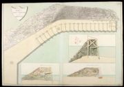
| Title: | Plan and Section of the Pier built at Fort Augustus in 1753 [copy] | |
| Name: | Skinner, William (Engineer) Read, William (Copyist) | |
| Survey: | 1753 | |
| Shelfmark: | MS.1647 Z.02/68b | |