Military Maps of Scotland (18th century)
Your search returned 5 records.
Ordered chronologically (undated items first).
| Field | Content | |
|---|---|---|
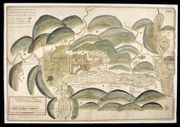
| Title: | Plan of Fort William with the country adjacent | |
| Name: | Johnson, Robert (Overseer) | |
| Survey: | [ca.1710] | |
| Shelfmark: | MS.1646 Z.02/24a | |
| Field | Content | |
|---|---|---|
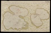
| Title: | A Plan of the Two Carrinburghs drawen on the place | |
| Name: | Johnson, Robert (Overseer) | |
| Survey: | [1717] | |
| Shelfmark: | MS.1648 Z.03/24a | |
| Field | Content | |
|---|---|---|
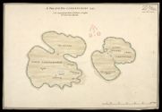
| Title: | A Plan of the Two Carrinburghs 1741 [copy] | |
| Name: | Johnson, Robert (Overseer) | |
| Survey: | 1741 | |
| Shelfmark: | MS.1648 Z.03/24b | |
| Field | Content | |
|---|---|---|
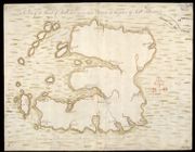
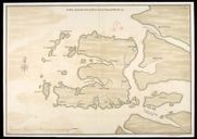
| Title: | A Plan of the Island of Mull with the adjacent Islands Drawen on the place | |
| Name: | Johnson, Robert (Overseer) | |
| Survey: | [1741] | |
| Shelfmark: | MS.1648 Z.03/23a | |
| Field | Content | |
|---|---|---|
| Title: | A Plan of the Island of Mull with the adjacent Islands [copied] 1741 | |
| Name: | Johnson, Robert (Overseer) | |
| Survey: | 1741 | |
| Shelfmark: | MS.1648 Z.03/23b | |