Military Maps of Scotland (18th century)
Your search returned 4 records.
Ordered chronologically (undated items first).
| Field | Content | |
|---|---|---|
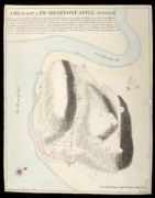
| Title: | A Draught of Dumbarton Castle Anno 1708 [copy] | |
| Name: | Field, John (Copyist) | |
| Survey: | 1708 | |
| Shelfmark: | MS.1647 Z.02/71b | |
| Field | Content | |
|---|---|---|
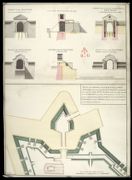
| Title: | Plan of the front on the Entrance to Fort William, representing the Main Gate Way as proposed to be rebuilt with the Wing Walls sustaining the ground of the Rampart on each side of the Entrance. And the manner proposed for forming the Earth Work of the R | |
| Name: | Campbell, Dugal (Engineer) Field, John (Copyist) | |
| Survey: | [1744] | |
| Shelfmark: | MS.1646 Z.02/27b | |
| Field | Content | |
|---|---|---|
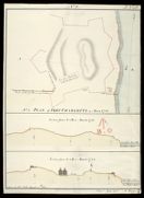
| Title: | Plan of Fort Charlotte in March 1781 No. 1; Section from A to B in March 1781; Section from A to B January 1783 [copy] | |
| Name: | Frazer, Andrew (Engineer) Field, John (Copyist) | |
| Survey: | 1812 | |
| Shelfmark: | MS.1649 Z.03/48b | |
| Field | Content | |
|---|---|---|
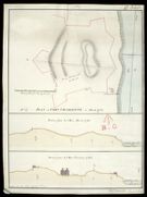
| Title: | Plan of Fort Charlotte in March 1781 No. 1; Section from A to B in March 1781; Section from A to B January 1783 [copy] | |
| Name: | Frazer, Andrew (Engineer) Field, John (Copyist) | |
| Survey: | 1812 | |
| Shelfmark: | MS.1649 Z.03/48c | |