Military Maps of Scotland (18th century)
Your search returned 3 records.
Ordered chronologically (undated items first).
| Field | Content | |
|---|---|---|
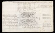
| Title: | Sketch of the Carpenters Work in Ten Feet Running of the Pier at Fort George | |
| Name: | Shipley, Sir Charles (Engineer) Elphinstone, Sir Howard (Engineer) | |
| Survey: | 1787 | |
| Shelfmark: | MS.1650 Z.46/57f | |
| Field | Content | |
|---|---|---|
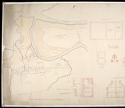
| Title: | [Map of area around Fort William showing] Boundary of the Crown lands; plans, elevations and sections of Ordnance Store and Magazine; Table of Reference [showing] Nature of the Encroachment, How Occupied, Occupiers Name, and Rent & to Whom Paid | |
| Name: | Elphinstone, Sir Howard (Engineer) | |
| Survey: | 1818 | |
| Shelfmark: | MS.1650 Z.46/21 | |
| Field | Content | |
|---|---|---|
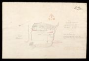
| Title: | Fort William; plan shewing the situation and extent of the grant made to the Episcopal Inhabitants by the Board in Decr. 1815 | |
| Name: | Elphinstone, Sir Howard (Engineer) | |
| Survey: | 1818 | |
| Shelfmark: | MS.1650 Z.46/22 | |