Military Maps of Scotland (18th century)
Your search returned 4 records.
Ordered chronologically (undated items first).
| Field | Content | |
|---|---|---|
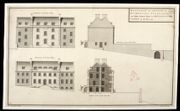
| Title: | Elevations and Section for a Governours, Storekeeper, and Master Gunner's House at Edinborough Castle for the year 1740 [copy] | |
| Name: | Campbell, Dugal (Engineer) Deleny, John (Copyist) | |
| Survey: | 1740 | |
| Shelfmark: | MS.1645 Z.02/05a | |
| Field | Content | |
|---|---|---|
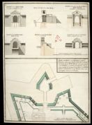
| Title: | Plan of the Front on the Entrance to Fort William, representing the Main Gate Way as proposed to be rebuilt with the Wing Walls sustaining the ground of the Rampart on each side of the Entrance. And the manner proposed for forming the Earth Work of the R | |
| Name: | Campbell, Dugal (Engineer) Deleny, John (Copyist) | |
| Survey: | [1744] | |
| Shelfmark: | MS.1646 Z.02/27a | |
| Field | Content | |
|---|---|---|
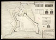
| Title: | Plan of Fort William 1745 [copy] | |
| Name: | Campbell, Dugal (Engineer) Deleny, John (Copyist) | |
| Survey: | 1745 | |
| Shelfmark: | MS.1646 Z.02/29b | |
| Field | Content | |
|---|---|---|
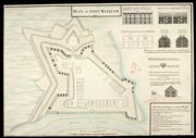
| Title: | Plan of Fort William 1745 [copy] | |
| Name: | Campbell, Dugal (Engineer) Deleny, John (Copyist) | |
| Survey: | 1745 | |
| Shelfmark: | MS.1646 Z.02/29c | |