Military Maps of Scotland (18th century)
Your search returned 3 records.
Ordered chronologically (undated items first).
| Field | Content | |
|---|---|---|
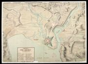
| Title: | A Plan of Fort Augustus with the adjacent Lands 1750 | |
| Name: | Daubant, Abraham (Engineer) | |
| Survey: | 1750 | |
| Shelfmark: | MS.1647 Z.02/67a | |
| Field | Content | |
|---|---|---|
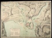
| Title: | A Plan of Fort Augustus with the adjacent lands 1750 [copy] | |
| Name: | Daubant, Abraham (Engineer) | |
| Survey: | 1750 | |
| Shelfmark: | MS.1647 Z.02/67b | |
| Field | Content | |
|---|---|---|
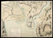
| Title: | A Plan of Fort Augustus with the adjacent lands 1750 [copy] | |
| Name: | Daubant, Abraham (Engineer) Rogerson, William M. (Copyist) | |
| Survey: | 1750 | |
| Shelfmark: | MS.1647 Z.02/67c | |