Military Maps of Scotland (18th century)
| Field | Content |
|---|---|
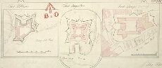
| Title: | Fort William; Fort Augustus; Fort George, Inverness |
| Name: | Romer, John Lambertus (Engineer) Jackson, Leonard (Draughtsman) |
| Description: | 1 manuscript map ; 174 x 403 mm., on sheet, 184 x 429 mm. |
| Original Survey: | [ca.1729-46] |
| Date on Map: | [ca.1729-46] |
| Placename: | Fort William, Fort Augustus, Fort George (Inverness) |
| Parish: | Kilmallie, Boleskine and Abertarff, Ardersier |
| County: | Inverness-shire |
| Shelfmark: | MS.1646 Z.02/31c |
| Zoom Into Map: | Click on the map to view in greater detail. |